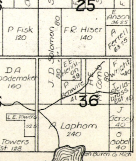
Historic plat maps are useful in seeing ownership of rural land parcels. A search on the web will pull of the site Historical Maps Works where townships maps can be found and pulled up for viewing; they're also available for purchase. The older maps also often show houses, lakes and rivers. Topographic maps, usually the best reference source for land features (including cemeteries, churches, schools, barns, houses) aren't available for Michigan areas before the 1940's, sadly, so are limited in their applicability for historical research. But in the 1950's the plat books get strange and I can't interpret them - no houses shown, and land owners displayed in a confusing manner; can't even find any clarification in the plat book itself.
So here is ownership of Mott property based on 3 old plat maps for Rutland Almena Township, Van Buren County:


No comments:
Post a Comment