Friday, November 20, 2020

BERNARD W. BAKER SANCTUARY - overview


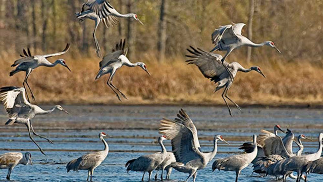
This is North America's first bird sanctuary dedicated to the conservation of Sandhill Cranes, established in 1941. It spans some 980 acres in Calhoun County and is the second largest property owned and managed by Michigan Audubon. The centerpiece is the 200 acre Big Marsh Lake, a restored wetland flooding. In the preserve are other ponds, streams, marshes, tamarack swamp. wet meadow, prairie restoration area.


More than 200 species of birds have been recorded. Reported were a pair of breeding trumpeter swans and an active eagle nesting site.

The Meadow and Marshland Trail was created in 1996. Trails are kept mowed. Lots of wildlife in the area, not only birds.

21145 15 Mile Rd., Bellevue Convis Twp T1S, R6W Sec 10,11,14 &15


In 2016 an additional 80 acres were added, the Mabelle Isham Shagbark Trails. A collaborative effort through various conservation agencies arranged purchase of the property from her daughter who inherited the property.

And the most recent development is a conservation easement on farm land east of the lake. Southwest Michigan Land Conservancy arranged this working with the property owner, the Holcombs. Big Marsh Farm is a 476 acre addition to protected lands of Baker Sanctuary. 

More about the benefactors in a later post...


Monday, November 16, 2020

MILDRED HARRIS SANCTUARY - Overview

A small relatively unnoticed preserve of 40 acres. It has a mature Beech-Maple forest most likely unlogged - ever! The dense tree canopy fosters an understory covered mainly with small flowering plants such as trout lily, spring beauty, squirrel corn, trillium, wild leek. On the east side is an open field.


Audubon still refers to a trail system under consideration - unlikely to happen. Actually it's very nice to make my way across and around fallen trees and just wander thru the site. A bit difficult when the dog's leash hooks on small seedling trees. Another provision of the property transfer was that controlled burns were to be done regularly in the field to stave of tree encroachment; never done. Surprisingly there are only some juniper and some bushes taking hold. The strip of land between the field and forest is impossible to cross due to a line of brambles.

7015 W 'F' Ave, Kalamazoo Alamo Twp T1S R12W Sec 34

Sunday, November 15, 2020

Harris Original Land Patent Holder - Doubleday

Land patents are explained in the Mott post about John McDermid. 

The first person to claim this parcel from the U.S. government  was Demas Abner Doubleday 1786-1862 of Otsego Co., New York in 1839. No surprise for yet another New York resident taking advantage of cheap land prices of $1.25 an acre to engage in land speculation. 

Conceivably Demas may have visited this land, but the family isn’t mentioned in historical records of Alamo Township. However it is his sons who enter the annals of Kalamazoo history, but not as farmers. Any baseball fans out there? One of his sons, Lt. Abner D. Doubleday is rumored to have been the inventor of baseball! It is a disputed rumor so will only get mention. His role in Kalamazoo is of more significance.

The sons of Demas formed Doubleday & Bros Co. in 1898 in Kalamazoo, an office supply company. Lt. Abner D. Doubleday 1829-1903 is buried in Riverside Cemetery with his wife Maria Ruby. 

In 1873 the plat map shows the property owned by John Harris. Ass to when ownership was actually transferred can be determined thru examination of the land records. That requires a visit to the Kalamazoo County Registrar of Deeds and lessening of the current raging pandemic.


RONALD W. WARNER SANCTUARY - Overview

Here are 108 acres of woods on Glass Creek, just a few miles north of Otis Farm Sanctuary. There are old growth beech, oak and tulip trees at the northern end of the property, just follow the trail until just after the first bridge across the creek. Trail is 1.7 miles start on Erway Rd to exit on Hart Rd. Easiest is to return to the parking lot via Hart & Erway Roads, also much shorter distance.

2500 Erway Rd., Hastings, Rutland Twp T3N R9W Sec 29

An unnamed pond is on the property and supposedly there was a floating bog, apparently gone now. But the trees are extraordinary! You find yourself in a location where you'll not hear any sounds of civilization. Is this that early settlers experienced? But they were much more used to quiet unlike people nowadays who can't function without a minimum of constant white noise in their life. 

Breeding birds inhabiting this area typically are Acadian Flycatchers, Ovenbirds, Scarlet Tanagers and Yellow-billed Cuckoos. Cuckoos!  Really! 


I'm convinced the deteriorating white house on Hart Rd was built by the Warner family.  More about the family background in a later post. This is yet another property that was in the same family for over 100 years. I couldn't bear to take a photo of the west side where the wall is rotted out.


Saturday, November 14, 2020

Mott Sanctuary - Jacob Erkenbeck

The History of Berrien and Van Buren Counties 1880 has the biography of Jacob and his wife.  "As one of the early settlers of this portion of Van Buren County, he is entitled to honorable mention. He was a native of the State of New York, and was born March 18, 1801. Dec. 19, 1824, he was married to Helen Cole, who survives him. Mr. and Mrs. Erkenbeck were the parents of eight children, as follows: Cornelius, born Oct. 18, 1825; Maria, born June 25, 1827, died Aug. 22, 1866; Eleanor, born Nov. 17, 1829; Catharine, born Nov. 25, 1831; Wilham, born Feb. 10, 1834; Nicholas, born Feb. 25, 1836, died May 23, 1866; Martin, born Sept. 14, 1838; John, born June 1, 1845. In the fall of 1846, Mr. Erkenbeck removed to Michigan with his family, and settled on the farm now occupied by his widow. He purchased eighty acres of land, and paid for it by trading off his team and wagon. It was very much of a struggle for him to take care of his family, but he finally triumphed over hardships and difficulties, and at his death, which occurred Nov. 8, 1877, hc left them in good circumstances. His occupation was that of a farmer, and in it he was ultimately successful. Both he and his wife were members of the Methodist Episcopal Church."

And here they are: 


People in these type drawings all look the same; maybe they did in real life, too.


Both parents along with Eleanor and Nicholas are buried in the Almena Cemetery. Note that names are misspelled on the tombstone! But is it misspelled? Jacob's will has his name as Erkenbreck. Helen's name has double l. Wonder if this might be due to having to order tombstones by mail as there wasn't a local monument maker.


Almena Township Cemetery


Mott - Why Is It named for Martha?

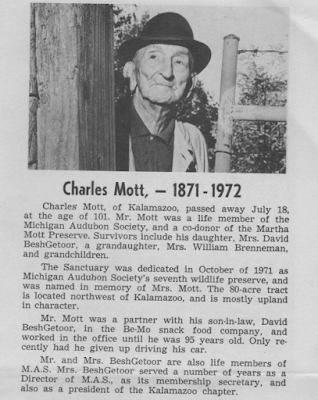
Title for the property transferred to Michigan Audubon October 1971, among the first properties donated to become bird sanctuaries. The donor was 100 year old Charles Mott who purchased the 80 acres in 1955 as it reminded him of Calhoun Co, where he grew up. His family never lived here nor farmed the land so it was essentially untouched since 1955. They did have a vineyard along 44th St, just about where the parking lot now sits. And they planted some vegetables that were left to ripen and feed the wildlife. The property donation was in memory of his wife Martha, who liked nature.
Charles co-owned the property with his daughter, Mrs. Leone M. BeshGetoor.  Charles and Leone's husband founded Be-Mo Potato Chip Co. at 806 Cobb in Kalamazoo. Later the company general manager was William Brenneman, husband of Jenna BeshGetoor. The company filed for bankruptcy in 1984 after 54 years of business.
Martha M., nee Rocho, died Feb 13, 1956. Charles died 1972 at age 101. They both were born near Ceresco where they met at a dance. Later married on Christmas Day. First they farmed, then ran a general store, then Charles was a deputy sheriff in Calhoun Co. They moved to Kalamazoo and in 1931 opened BeMo with his son-in-law, David BeshGetoor.


Among plans discussed for this preserve were a small lodge and caretakers quarters. Nothing came of that. Thanks to a local troop of Boy scouts there is at least a trail.


OTIS FARM BIRD SANCTUARY - Overview

First time I heard the name of this sanctuary I was totally confused. I knew Audubon had sanctuaries, but why would they have one for 'farm birds'? Is it a refuge for old hens, no longer egg layers? Ah, a case of where a comma is useful. It is the Otis Farm, bird sanctuary!


Here are 128 acres of rolling fields, forest, marshland, stream, kettle hole marshes and several springs. And even a rustic cabin for rent. The old barn and house still stand and the sanctuary manager gets to live in the house.

The property sits between Yankee Springs Recreation Area and the Barry State Game Area. Nearest neighbor is a farm half mile down the road and that's it for a couple of miles. Most of the old surrounding farms were bought up by the state back in the 1940's.

Grand opening was Oct 25, 2002. The sanctuary came to be largely due to the friendship that developed between Bob & Mildred Otis with Loretta Gold, then president of the Michigan Audubon Society.

Notable birds species are Cerulean Warbler, and Henslow's Sparrow. I've seen Sandhill Cranes passing overhead. I hear birds, but trying to see enough of one to actually make an identification it is a challenge. It's nice just to hear them and watch the grass wave in the wind.

It is disappointing that the Michigan Audubon website doesn't even post a photo and there is no information about the generous donors, not for any of the sanctuaries, hence this blog.

3560 Havens Road, Hastings Rutland Twp T3N R9W Sec 32 & 33

Walking the 1.2 mile trail I was reminded a bit of the Scottish Highlands. Rolling hill, groups of brightly colored flowers among the grasses.


Friday, November 13, 2020

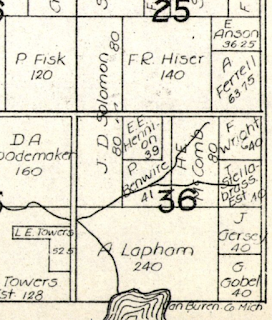
Mott Sanctuary - Plat Maps - What do we find

Historic plat maps are useful in seeing ownership of rural land parcels. A search on the web will pull of the site Historical Maps Works where townships maps can be found and pulled up for viewing; they're also available for purchase. The older maps also often show houses, lakes and rivers. Topographic maps, usually the best reference source for land features (including cemeteries, churches, schools, barns, houses) aren't available for Michigan areas before the 1940's, sadly, so are limited in their applicability for historical research. But in the 1950's the plat books get strange and I can't interpret them - no houses shown, and land owners displayed in a confusing manner; can't even find any clarification in the plat book itself. 

So here is ownership of Mott property based on 3 old plat maps for Rutland Almena Township, Van Buren County:

1873 Jacob Erkenbeck - note a house is shown

1912 Thos. Adamson - house about where parking sits

1930 J.D. Solomon (map leaves out all house info)

Shows a building but who is the owner?


Wednesday, November 4, 2020

Mott's Original Land Patent Holder - McDermid

Land patents are the deed document when land was first purchased from the U.S. government. The public land survey system, Rectangular Survey System, is the method used to plat real property for sale. It was created by the Land Ordinance of 1785 to survey land obtained thru the Treaty of Paris 1783 with King George III (the crazy one). It covered the lands of the Northwest Territory. NO! Not Oregon! The Northwest Territory in 1700's was Michigan, Wisconsin, Ohio, Indiana and Illinois. It was wild country back then, very wild and difficult for travel, full of wolves and Indians and swamps full of mosquitos. 

The land survey divided a territory into 36 square mile townships in a county. Land surveys of Van Buren County were in 1830. Survey details are on the Bureau of Land Management website: glorecords.blm.gov.

Now that we have that all clear, let's see who first owned the land that became Mott Sanctuary. John McDermid of Livingston County, New York purchased these very 80 acres in 1839, the West 1/2 of the NW 1/4 of section 36.

McDermid was born 1808 in Ballston in eastern New York. In 1835 he settled in Cambria, Hillsdale County, Michigan with his brother Andrew and built a sawmill. Later built more mills in what became known as Cambria Mills. Known as a farmer, miller and Republican (remember this was then the party of Lincoln). McDermid was the state Senator from Hillsdale Co. 1861-2. He died May 16, 1868.

So McDermid never lived in Almena Township on his 80 acres. So who took possession next? In 1873 owner was Jacob Erkenbach (more on him later) but that leaves some 38 years in between.


                                            Original land survey of south Almena Township.


McDermid Land Patent 1839


Otis Sanctuary - Land Ownership Questions and Answers

Farm Silos - glazed & concrete block The original land patents for the acreage that became Otis farm was first sold in 1856, fairly late...