Casapar II |
Caspar III |
Jackson H.S. 1922 |
Casapar II |
Caspar III |
Jackson H.S. 1922 |
Methodist Church (now Democrat Headquarters) |
On Sept 27, 1886 two couples were married in a double ceremony at the Hastings Methodist Church.
They were Fred & Lucille Otis and William & Mattie Havens. Lucille was sister of William Havens. Mattie was cousin to Fred Otis. The Havens had their farm just up the road from the Otis place on Glass Creek.On Sunday Sept 26, 1936 they celebrated their 50th wedding anniversaries. The whole community helped them celebrate. It made the news in the Battle Creek Enquirer and the Detroit Free Press!
Otis and Erway couples 1936 |
The Otis lived in the same home in Rutland Township for the last 48 years. Fred was born in Rutland Township and Luella was born in Washtenaw Co. Their family in 1936 consisted of 10 children, 25 grandchildren, and 2 great grandchildren.
William was born in Jackson Co 72 years ago; Mattie born in Rutland Twp. They had 3 children, 6 grandchildren, 2 great grandchildren. Their farm was in adjacent Hope Twp.
In celebration they held an open house for friends Sunday afternoon and evening. As pointed out in the Free Press, anybody in either family was to some extent related to anyone in the other family!
Neither couple left Michigan more than once in their married lives. The Havens once visited Wisconsin and the Otises on Sunday drove to Indiana.
A visit to Rutland Township cemetery on M-43 just NE of Hastings shows the deep roots of these families, together in the township for all eternity. There is a nice aspect to having so many family and friends around one in death, isn't there.
Fred and Luella had a large family as was common in the Otis family known for their fecundity far back in the Vermont/Quebec days. In 1910 they posed for photo. I note how the women all wear white, and managed to keep it immaculate looking having no modern washing conveniences; clearly they were better skilled at doing wash than many of us nowadays. Robert was born a year after this photo was taken.
Mildred Gruensch |
Norm and Millie at the Otis Farm Sanctuary |
His name came up in my research on Baker and Haehnle Sanctuaries. It warranted further investigation as his was the only name to come up in two sanctuaries.
Lawrence Harvey Walkinshaw was born on the family farm in Convis Twp 1904. After graduating from Olivet College he went on to University if Michigan getting his dentistry degree in 1929. He had his practice in Battle Creek until 1968.
The Walkinshaw family has a long history in the township starting with his great grandparents James Honorable and Jemina Walkinshaw. Both born in Scotland and in 1842 immigrated to Marshall, Michigan. They moved to a small farm in Convis Twp. The lineage goes James, Charles, Beaton who married Eva Marie Grinnell and from whence came Lawrence. The plat map shows many Walkinshaws living around the Sanctuary area. So Larry knew this landscape well from his youth. Additionally he actively birded in the area east of Jackson that became the Haehnle Sanctuary.
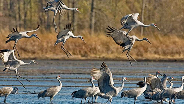
The draw for him were cranes. He leaves a legacy of distinguished ornothology. His distinguished career is covered in this account of his work: IN MEMORIAM: LAWRENCE HARVEY WALKINSHAW, 1904-1993 (unm.edu). Not only did he provide valuable research on cranes, but also Kirkland warblers and field sparrows. He saw the cranes restored but the prairie chicken disappear.
Sadly, there is no sanctuary named for him. It can't be said that he left a greater legacy than those who legacy was to have purchased land.
While the rest of his ancestry is buried in Austin Cemetery, Convis Twp, the doctor and his wife Clara Mae Cartland are buried in Holt, MI. For 40 years he did Christmas Bird Counts in Battle Creek then another 20 years of counts in Lakeland, Florida.
A debit is owed to Larry for his ornithological legacy and the beautiful places he helped people become aware of their unique value.
The Otis's of Glass Creek
This appeared in Vol. IV Issue 6 Nov/Dec 2006 edition of The Dragonfly (publication of Michigan Audubon Otis Sanctuary)
Around 1855 three Otis brothers, Feril, Philander, and Parshal came to Glass Creek in South West Rutland Township. Of all their hundreds of descendants, only Robert (Bob) H. Otis, grandson of Parshal and son of Fred and Luella Otis, still lives in the area, on the family farm. Gone are Feril and Philander, their farms now part of the State Game Preserve, the fine, big houses, their large families scattered. The name lives on in Otis Lake and Otis Lake Road. The site of the old Otis Schoolhouse is lost in second growth forest.
Parshal Otis did not settle down immediately but worked in the lumber camps north of Grand Rapids. In time he married Betsey Foreman by whom he had four sons: Fred (our father), Clarence, Delbert, and Ray. They lived on Otis Lake Road, the spot marked now only by a great, spreading lilac bush.
In 1880 they moved east of Glass Creek to a farm consisting of a great marsh along the creek, the rest glacial hills. Here, in 1886, our father married Luella Havens and took on the farm, the mortgage, and the care of his aging parents. And here their children were born, all twelve of them.
It was against the advice of his anxious uncles that our father determined to make a go of farming those hills. But he loved that marsh and those hills and they were his.
In the early years he taught country school in the winter term, and he could always add to the farm income doing things for neighbors, which they couldn't. He could hang paper, work with concrete, butcher - whatever was needed. He was a good salesman too, and he sold hand powered washing machines, home lighting equipment, milking machines, furnaces, silos, plaster, stock in several creameries.
Fred Otis was a good farmer, and because he respected the land it cooperated with him. With good farm practices he built up his soil until it produced crops of which he could be and was, proud.
Bob, like his father, loved the marsh and the hills and all the creatures that live there. He, too, was a good farmer but gave it up to be a carpenter and skilled worker with wood.
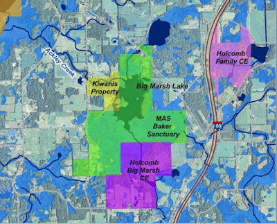
Larry Holcomb is a retired wildlife biologist who grew up in Olivet. He hunted, fished and roamed the lands that became Baker Sanctuary. He studied at MSU where he received a PhD; later he became a Certified Wildlife Specialist with the Michigan DNR. In 2008 this 476 acre property called Big Marsh Lake was up for sale. It borders Baker Sanctuary on the east. Big Marsh Farm has forested and prairie uplands along with 140 acres of wetland. The Holcombs purchased it. In 2017 working with Southwest Michigan Land Conservancy, they secured a conservation easement for this special property. The Holcombs have another property just the other side of I-69 on which they previously placed conservation easement.
Mabelle Isham was a wildlife rehabilitator and Michigan Audubon board member. She owned 80 acres, Shagbark Trails, next to the sanctuary. Her daughter inherited the property and sold it to Audubon in 2016.
The Meadow and Marshland Trail was created in 1996. Trails are kept mowed. Lots of wildlife in the area, not only birds.
21145 15 Mile Rd., Bellevue Convis Twp T1S, R6W Sec 10,11,14 &15
And the most recent development is a conservation easement on farm land east of the lake. Southwest Michigan Land Conservancy arranged this working with the property owner, the Holcombs. Big Marsh Farm is a 476 acre addition to protected lands of Baker Sanctuary.
More about the benefactors in a later post...
A small relatively unnoticed preserve of 40 acres. It has a mature Beech-Maple forest most likely unlogged - ever! The dense tree canopy fosters an understory covered mainly with small flowering plants such as trout lily, spring beauty, squirrel corn, trillium, wild leek. On the east side is an open field.
Audubon still refers to a trail system under consideration - unlikely to happen. Actually it's very nice to make my way across and around fallen trees and just wander thru the site. A bit difficult when the dog's leash hooks on small seedling trees. Another provision of the property transfer was that controlled burns were to be done regularly in the field to stave of tree encroachment; never done. Surprisingly there are only some juniper and some bushes taking hold. The strip of land between the field and forest is impossible to cross due to a line of brambles.
7015 W 'F' Ave, Kalamazoo Alamo Twp T1S R12W Sec 34
Conceivably Demas may have visited this land, but the family isn’t mentioned in historical records of Alamo Township. However it is his sons who enter the annals of Kalamazoo history, but not as farmers. Any baseball fans out there? One of his sons, Lt. Abner D. Doubleday is rumored to have been the inventor of baseball! It is a disputed rumor so will only get mention. His role in Kalamazoo is of more significance.
The sons of Demas formed Doubleday & Bros Co. in 1898 in Kalamazoo, an office supply company. Lt. Abner D. Doubleday 1829-1903 is buried in Riverside Cemetery with his wife Maria Ruby.
In 1873 the plat map shows the property owned by John Harris. Ass to when ownership was actually transferred can be determined thru examination of the land records. That requires a visit to the Kalamazoo County Registrar of Deeds and lessening of the current raging pandemic.
Here are 108 acres of woods on Glass Creek, just a few miles north of Otis Farm Sanctuary. There are old growth beech, oak and tulip trees at the northern end of the property, just follow the trail until just after the first bridge across the creek. Trail is 1.7 miles start on Erway Rd to exit on Hart Rd. Easiest is to return to the parking lot via Hart & Erway Roads, also much shorter distance.
2500 Erway Rd., Hastings, Rutland Twp T3N R9W Sec 29
An unnamed pond is on the property and supposedly there was a floating bog, apparently gone now. But the trees are extraordinary! You find yourself in a location where you'll not hear any sounds of civilization. Is this that early settlers experienced? But they were much more used to quiet unlike people nowadays who can't function without a minimum of constant white noise in their life.
Breeding birds inhabiting this area typically are Acadian Flycatchers, Ovenbirds, Scarlet Tanagers and Yellow-billed Cuckoos. Cuckoos! Really!
The History of Berrien and Van Buren Counties 1880 has the biography of Jacob and his wife. "As one of the early settlers of this portion of Van Buren County, he is entitled to honorable mention. He was a native of the State of New York, and was born March 18, 1801. Dec. 19, 1824, he was married to Helen Cole, who survives him. Mr. and Mrs. Erkenbeck were the parents of eight children, as follows: Cornelius, born Oct. 18, 1825; Maria, born June 25, 1827, died Aug. 22, 1866; Eleanor, born Nov. 17, 1829; Catharine, born Nov. 25, 1831; Wilham, born Feb. 10, 1834; Nicholas, born Feb. 25, 1836, died May 23, 1866; Martin, born Sept. 14, 1838; John, born June 1, 1845. In the fall of 1846, Mr. Erkenbeck removed to Michigan with his family, and settled on the farm now occupied by his widow. He purchased eighty acres of land, and paid for it by trading off his team and wagon. It was very much of a struggle for him to take care of his family, but he finally triumphed over hardships and difficulties, and at his death, which occurred Nov. 8, 1877, hc left them in good circumstances. His occupation was that of a farmer, and in it he was ultimately successful. Both he and his wife were members of the Methodist Episcopal Church."
And here they are:
People in these type drawings all look the same; maybe they did in real life, too.
Both parents along with Eleanor and Nicholas are buried in the Almena Cemetery. Note that names are misspelled on the tombstone! But is it misspelled? Jacob's will has his name as Erkenbreck. Helen's name has double l. Wonder if this might be due to having to order tombstones by mail as there wasn't a local monument maker.
Almena Township Cemetery |
Historic plat maps are useful in seeing ownership of rural land parcels. A search on the web will pull of the site Historical Maps Works where townships maps can be found and pulled up for viewing; they're also available for purchase. The older maps also often show houses, lakes and rivers. Topographic maps, usually the best reference source for land features (including cemeteries, churches, schools, barns, houses) aren't available for Michigan areas before the 1940's, sadly, so are limited in their applicability for historical research. But in the 1950's the plat books get strange and I can't interpret them - no houses shown, and land owners displayed in a confusing manner; can't even find any clarification in the plat book itself.
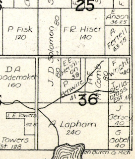
So here is ownership of Mott property based on 3 old plat maps for Rutland Almena Township, Van Buren County:
Land patents are the deed document when land was first purchased from the U.S. government. The public land survey system, Rectangular Survey System, is the method used to plat real property for sale. It was created by the Land Ordinance of 1785 to survey land obtained thru the Treaty of Paris 1783 with King George III (the crazy one). It covered the lands of the Northwest Territory. NO! Not Oregon! The Northwest Territory in 1700's was Michigan, Wisconsin, Ohio, Indiana and Illinois. It was wild country back then, very wild and difficult for travel, full of wolves and Indians and swamps full of mosquitos.
The land survey divided a territory into 36 square mile townships in a county. Land surveys of Van Buren County were in 1830. Survey details are on the Bureau of Land Management website: glorecords.blm.gov.
Now that we have that all clear, let's see who first owned the land that became Mott Sanctuary. John McDermid of Livingston County, New York purchased these very 80 acres in 1839, the West 1/2 of the NW 1/4 of section 36.
McDermid was born 1808 in Ballston in eastern New York. In 1835 he settled in Cambria, Hillsdale County, Michigan with his brother Andrew and built a sawmill. Later built more mills in what became known as Cambria Mills. Known as a farmer, miller and Republican (remember this was then the party of Lincoln). McDermid was the state Senator from Hillsdale Co. 1861-2. He died May 16, 1868.
So McDermid never lived in Almena Township on his 80 acres. So who took possession next? In 1873 owner was Jacob Erkenbach (more on him later) but that leaves some 38 years in between.
A former farmstead and woodlot in Almena Township, Van Buren County, this 80 acre sanctuary has a fine stand of oaks, hickory and walnut. There are open and shrubby fields and Hayden Creek along the south boundary. Typical southern Michigan birds such as Eastern Bluebirds, Field Sparrow and Red-eyed Vireos are found here.
View of Hayden Creek |
That's the official Audubon version. Their sanctuary descriptions are very brief, provide no information about the property donor, and are out of date. I'll try to remedy that in the blog.
I've yet to see hickory trees; better look closer. The other day I discovered a Mountain Ash! One singular tree. Possibly a result of a tree is in the subdivision that parallels the east boundary and some hungry bird ate the berries then came here to poop. In Scotland it’s called a Rowan Tree with much folklore and myths.
The Mt. Ash is on the edge of a unique depression, small crater. There aren't any sizeable trees in it, but it has a row of Red Pine, the ubiquitous planation tree widely planted in the 1930's. So the depression may not be a natural feature. What did they dig out?
There is now a marked loop, with a well worn trail thru the grasslands. Yes the fields are getting shrubby with autumn olives but there is a nice stand of bluestem at the north end of the big field. And the goldenrod is lovely.
44th Ave at 24th St, Mattawan Almena Twp. T2S R13W Sec 36
Farm Silos - glazed & concrete block The original land patents for the acreage that became Otis farm was first sold in 1856, fairly late...